

Threxx
-
Posts
5,276 -
Joined
-
Last visited
Content Type
Profiles
Forums
Gallery
Downloads
Events
Blogs
Posts posted by Threxx
-
-
Nope, not a cowboy. I just recognize a good train and know what to do with it. I don't take any chances with something I'm not sure would stop safely within station limits.
OK.
What's your opinion about the R32/R38 cars?
0 -
Here's a new route running in between Forest Avenue and Victory Blvd in SI, running from the Teleport to St. George (Since it runs on the North Shore, we can call it the S49)
Eastbound: South Avenue-Fahy Avenue-Lamberts Lane-Richmond Avenue-Deppe Place/Watchogue Road-Willowbrook Road-College Avenue-Manor Road-Forest Avenue-Victory Blvd-Bay Street.
Westbound: Bay Street-Victory Blvd-Forest Avenue-Manor Road-College Avenue-Willowbrook Road-Watchogue Road/Deppe Place-Richmond Avenue-Goethals Road North-South Avenue.
I've edited the route and I removed the unnecessary Clove Road-Martling Ave turn.
0 -
In sheer braking power, 68A -> 160 Alstom -> 160 Siemens -> 68. The greatest difference of notice is between the Alstom and Siemens sets.
68A are also faster cars than 68, and have among the fastest units in the SMEE (There are some R32 cars up there too, but the problem is because of the married pair setup, its difficult to figure out which pairs are faster than others, and its nearly impossible and purely chance to get all the fast pairs on a single consist).
I had a good motor today 5076 = 53mph bet 34th - W4, 47mph going into Newkirk s/b (not down the hill), 48mph at Sheepshead Bay s/b. The latter two numbers are on flat track. Fastest 68A Ive ever had. I wish I had it going back north, might have had a shot at 55 n/b at Newkirk.
Do you try to race your trains? :eek:
0 -
A new "Black (V)" or, a GG?
 Myrtle-Brighton line that would run via the existing portion of the Myrtle Avenue El (including a rebuild of the upper level of the Myrtle Avenue (J)/(M)/(Z) station) and all stations along that portion of the line having their platforms lengthened to accommodate 600-foot trains and possibly 75-foot cars on that stretch of the Eastern Division ONLY):
 Such a new line after Myrtle Avenue upper level would then go via a new stretch of elevated track (stations along that part to be determined, though it would include a connection to the
 at either Myrtle-Willoughby or Bedford-Nostrand) connecting it to the existing Franklin Avenue Shuttle line, with the Franklin Avenue
  station becoming a through station and it as well as all other stations on the existing shuttle line also lengthened to handle 600-foot trains and that section re-built to two tracks from the current one. After Prospect Park, the new line continues to Coney Island as a local via the Brighton line, which would potentially allow the
  to become a 24/7 express to Brighton Beach while the
  would be a local with the new line to Coney Island, except late nights.
 In addition, a connection from the new line would be made to the Broadway-Brooklyn line to allow when necessary for the
, albeit with (obviously 60' cars) five-car 300-foot trains (unless future train orders go back to having the cars either being singles or linked together in pairs as opposed to four or five in a set) to access the Broadway-Brooklyn line when needed so the can operate via the  to 6th Avenue-57th Street.
What this line would do aside from eliminating the current Franklin Avenue
would be to eliminate the overnight shuttle between Metropolitan Avenue and Myrtle since this new "Black (V)" line would be covering that route as well as the rest as a 24/7 line.The cars for this line would be mainly R160s operating out of Coney Island Yard with possibly some R68s mixed in if the restriction on 75-footers on the existing Myrtle Avenue El portion were removed for that stretch ONLY.
It is a great idea. :cool: But, you would have to re-double track the Shuttle line between the Botanic Garden & Myrtle Ave.
(If you don't mind, I can incorporate this into some of my ideas! I will give you full credit.)

I can have the stops & route posted by Monday. (I also made some changes to the
section.)0 -
 & (I) LINES:
SEE RUSH HOUR PROJECT FOR OPERATING PATTERN INFO ON THESE LINES:
https://docs.google.com/document/d/1zDkEJ1d0N4DOh6jpW-S7sDP6zzaIBt1k7Uo9ax-M86I/edit
- ExpressBetween Sheepshead Bay (IRT-IND-BMT Double Decked/ Underground Terminal)
AND
South Yonkers
Norwood - 205 St
Wave Hill (Rush Hrs)
(I) - Local
Between Sheepshead Bay OR South 4 Street Terminal
AND
Fort George - 191 St
STOPS:
(Local, EXPRESS)
(Some transfers are also fantasy routes)
BROOKLYN...
SHEEPSHEAD BAY (Transfer to (
, , (8), <8>)Avenue Z (At Nostrand Ave)
Avenue X (At Nostrand Ave)
AVENUE U (At Nostrand Ave)
Gerritsen Beach (At Ave S & Gerritsen Avenue)
FILLMORE AVE (All stops, until noted are on Utica Ave)
Avenue N
Avenue K-Flatlands Ave
AVENUE H
Avenue D
CHURCH AVE
Winthrop Ave
Empire Bl
CROWN HEIGHTS
Bergen St
FULTON ST (At Stuyvesant Ave, until noted.)
Putnam Ave
Dekalb Ave
MYRTLE AVE (Transfer to (P), (X),
 , ,
, ,  )
)Flushing Ave
SOUTH 4th STREET-(METROPOLITAN AVENUE) (Transfer to
 ,
,  , (V)/(U), ,
  )
)MANHATTAN...
Pearl St (At Frankfort St)
CITY HALL (Transfer to
 ,
,  ,
,  , , , <R>, )(At Park Row)
World Trade Center-(Park Pl) (At Park Pl)
CHAMBERS ST (Transfer to
 ,
,  , (0),
  ,
,  ,
,  ,
,  ,
,  , (8), <8>,
  ) (At Greenwich St, until noted.)
CANAL/SPRING STS
Houston St
10 St-Christopher St
14 ST (Transfer to
 ,
,  , ) (10/Amsterdam Ave, until noted.
23 Street
28 Street
34 STREET
42 STREET - JAVITS CENTER
50 Street
60 ST-FORDHAM UNIV. (Transfer to (P), (X)
From here, except late nights, (H ) goes SUPER EXPRESS. These stops are marked like THIS.
66 Street
72 STREET (Transfer to (1 ), (2 ), (3 )
79 Street
86 Street
96 STREET
106 Street
116 Street
125 STREET
135 Street
145 STREET
155 Street
168 STREET (SUPER EXPRESS ON WEEKENDS ONLY)
174 Street
181 STREET
FORT GEORGE - 191 STREET (The (I) & (X - Except Rush Hrs) terminate here.)
H LINE SPLITS INTO BRANCHES.
205 St Branch: (+ (X - Rush Hours Only))
Dyckman St
Isham St
Marble Hill
Bronx...
W. 230 St
W. 238 St
Van Cortlandt Av West
Dickingson Ave
Moshulu Parkway
205 Street
Riverdale Branches: (+ (P))
Bronx...
KAPPOCK ST
Wave Hill:
231 St
245 St
Wave Hill
South Yonkers:
231 St
236 St
MANHATTAN COLLEGE PARKWAY
253 STREET
263 STREET
VALENTINE LANE
S BROADWAY
The color for the Amsterdam lines are, at the moment, tan.
K & HH lines coming soon!
0 -
No one has posted here in about a month now, I will put more stuff here, I've been working on the "Create your own bus route!" thread in the meantime.
EDIT: The first lines in about a month! SEE BELOW!
0 -
Nowhere near complete, but here's the first part of the Brooklyn Collaboration Map!
Here are the routes:
B50 and B53 - Created by ThrexxBus
B22 and B28 - Created by Me (The B22 is loosely based off Brooklyn Bus' B19 idea)
I guess and Threxx Bus and I could have collaborated better, our routes have could be considered redundant in a few places!

I will add in Coneyislandav7's routes and anybody else's fantasy routes. But I have finals soon, so yeah.
Please add the B18 route here: LOLOLOL
(Don't worry, I'm not trolling.)
0 -
And if anyone has any Manhattan fantasy bus routes, feel free to post the exact turn by turn directions and I'll create a map for it!
Can you do my M6 & M19? Here are the exact directions.
Southbound from The Bronx.
Broadway to Columbus Circle.
(M6 originates at 63 St & Bwy)
Around circle, then 59 Street to 7th Avenue.
South on 7th Avenue to 32 Street.
32 Street to Bway.
Bway to 18 St.
18 St to Park Ave S, continue onto B'way.
B'way to Bowling Green, continue onto State St.
M19SBS: M15SBS Terminal loop.
M6: Water St -> Broad St -> South St -> Whitehall St
Northbound from Ferry.
North from terminals onto State St.
State St -> Battery Pl -> Grennwich St -> Trinity Pl -> Church St -> 6th AV
6th Ave to 59 St.
M6:
Columbus Circle -> Central Pk S -> 63 St -> B'way (End of Route)
M19SBS:
Columbus Circle, then north on B'way to the Bronx.
SBS STOPS:
231 ST
225 ST
207 ST
181 ST, GW BRIDGE
168 ST
155 ST
145 ST
125 ST
106 ST
96 ST
86 ST
79 ST
72 ST
66 ST
63 ST
Columbus Circle
On 7th Avenue & Broadway (Going South)
57 ST
50 ST
42 ST
34 ST
32 ST & B’WAY
23 ST
14 ST
ASTOR PL
HOUSTON ST
CANAL ST
CHAMBERS ST
PARK ROW
FULTON ST
WALL ST
BOWLING GREEN
SOUTH FERRY
On Church St & 6th Avenue (Going North)
SOUTH FERRY
STATE ST
RECTOR ST
WTC
CHAMBERS ST
CANAL ST
W. 4 ST STATION
14 ST
23 ST
34 ST
42 ST
50 ST
57 ST
0 -
QBX55PREFERREDFordham Plaza to Laguardia AirportHere is one route that I think would set new standards in future planning. You heard of select bus services same Idea but this route/Service will be supierior to SBS so Let's name this one the "QBX55PREFERRED" in honor of the once great BX55!
It will start out In The Bronx at FORDHAM PLAZA and take 3rd av all the way down and over the 3rd av Br. Into Manhattan, making a left on Lexington another left on 125th and over the Triboro Br. Into Queens, making 2 quick stops in Astoria, one under the N train and the next on stienway before taking the grand central parkway express to all terminals at LAGUARDIA AIRPORT.
The busses would use priority right of way traffic signal technology along 3rd av and fewer stops along the way as well as prepaid fare collection at all "stations". This will effectively provide The Bronx with a direct connection to Queens and LGA while simultaneously enhancing service for Bronx riders within the 3rd av corridor, as well as providing a speedier alternative for riders along the M60 corridor and improving connections throughout the whoLe region in general
The stops are as follows: (Connctions are in parenthasis)
1. Fordham Plaza (MNRR, Bee-line 60,61,62 bx9,bx12,bx15,bx17,bx22,bx41,bx55 SBS12
2. 180 st/St. Barnabas Hospital (bx36)
3. Tremont av (bx40 42)
4. Claremont pkwy.(bx11)
5. 168 st (bx35)
6. 163 st/Boricua Village/Melrose (bx6,bx21)
7. 149 st/The Hub (2 and 5 subway,bx4,bx19,,bx41,bx55
8. 138 st (6 subwaybx1,bx2,bx21,bx32,bx33
9. 125 st/Lexington(4 5 and 6 subway MNRR bx15,m60,m100 101 102 103)
10. 125 St/ 2av (SBS15)
11. 31 st/ Astoria Blvd(N and Q subways)
12. Stienway st/Astoria Blvd
13. LGA Delta Terminal
14. LGA Terminal C
15. LGA Central Terminal
By the way I am a new Member so please accept this as my introduction
That is not a bad idea... I also have an idea for a Bronx-LGA route, but it comes from Co-Op City.
0 -
Here is another Brooklyn Route, the B18 B). Details are in the doc.
DOC:
https://docs.google.com/document/d/1bJHHXZzDfsBwSyrLtaKZaXhjSy4c32FCwNwpvgZ100E/edit
Here is a Manhattan pair of routes (
), a new M6 & a M19 SBS.The M6 & M19 use Gorgor's southern B'way route solution. (The red route.)
DOC:
https://docs.google.com/document/d/1pAwNwtSvl5BV47gj7YK06l0eVeaDwrc6DTmctUFWea0/edit
0 -
I guess and Threxx Bus and I could have collaborated better, our routes have could be considered redundant in a few places!

I will add in Coneyislandav7's routes and anybody else's fantasy routes. But I have finals soon, so yeah.
Thanks for your work! The routes aren't that redundant...
But, can you add my BQ1? It's express, and it is the same route as the B50 only it's non-stop between Church Ave & Lefferts Bl Air-Train Station.Here's the link: https://docs.google.com/document/d/1vE3HdPV75Ik5V3igYDXcgEfJUYo1kTVTBa_0CSUDQYg/edit
0 -
A revision of the M9!
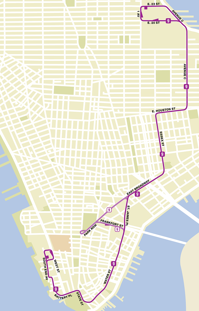
This one takes the current northbound terminal and both southbound terminals. But instead of two south M9 terminals, the new M9 would be reinstated down Water Street and loop around Battery Park City like it were prior to the 2010 cuts.
While the City Hall terminal's eliminated, the route isn't. During midday and rush-hour weekdays and Saturdays, the M9 would loop in Park Row. Heading to Battery Park City, it would turn on Frankfort Street. Heading northbound to the Veterans Hospital, it'd just keep traveling north on Park Row back to East Broadway.
That is one of the best ideas I have seen on this thread. :cool:
0 -
The stops on the P/X corridor are completed!
Link to google doc: https://docs.google.com/document/d/1eu8RPvNPJNT2krL_P3aZhlK3y1Akqw459MCcHBcNDbQ/edit
0 -
I have a new route, my usual GoogleDoc is not out yet.
Q26, via Conduit Blvds/Aves between Green Acres Mall & Bway Junction.
Certain trips travel to/from/via JFK Airport.
0 -
I don't think so really. Isn't the M35 mainly just mental patients going to/from the hospital? Any sane person either drives or takes a cab to Randall's Island because spending the extra money is definitely worth it than having to wait around 125th Street with a bunch of lunatics waiting for a bus.
Yeah, thats why I was not sure. I tried to get on it once & almost got hit in a fight. I would not want to drive that route if I were a bus driver.
0 -
Randall's Island: http://scaped.net/mta/islands.pdf
M36: Upper East Side, York Avenue
M38: Upper East Side, Madison/5th Avenues, 86th Street
M37: Upper West Side, Riverside Drive/West End Avenue, 96th Street
Some buses to Randall's Island run express via the West Side Highway between 72nd and 96th Streets
M39: Upper West Side, Central Park West, Columbus Circle
(
Not so sure about the M37/M39, but the M38 and especially the M36 would do quite well during the summer on weekends.
Also, none of these buses will make any stops anywhere close to 125th Street, that's what the M35 is for.
You could extend the M35 north to Washington Heights, or even the Bronx, but would it make money?
(P.S) Are these buses summer only, or all year?
0 -
[GMAPS]<iframe width="425" height="350" frameborder="0" scrolling="no" marginheight="0" marginwidth="0" src="http://maps.google.com/maps/ms?msa=0&msid=201703423907676287259.0004b5c88f0695f247277&ie=UTF8&ll=40.787354,-73.963013&spn=0.169933,0.103308&t=m&vpsrc=6&iwloc=0004b5c896c1be0ad96af&output=embed"></iframe><br /><small>View <a href="http://maps.google.com/maps/ms?msa=0&msid=201703423907676287259.0004b5c88f0695f247277&ie=UTF8&ll=40.787354,-73.963013&spn=0.169933,0.103308&t=m&vpsrc=6&iwloc=0004b5c896c1be0ad96af&source=embed" style="color:#0000FF;text-align:left">Manhattan Loop Idea</a> in a larger map</small>[/GMAPS]
M13 loop begins at South Ferry, follows M5 to Worth St, old M1 pattern to 9th St, then M5 to Worth St, then M15 pattern to South Ferry.
M30 loops follows M72 to Freedom Pl/68th St, then M57 to Madison Av, old M30 pattern to 72nd St.
M105 begins at Cloisters Museum or 190th St
Station, follows M4 to 178th St, then M100 to Kingsbridge Depot, then continue follows M100 to 179th St, then M4 back to 190th St (A)/Cloisters.So the M13 is to replace the M1 South Ferry section? It should go further north to 14 Street-Union Square. It could connect to the subway lines there & the shopping area.
(P.S. Good mission.)
0 -
Two new Manhattan fantasy routes!
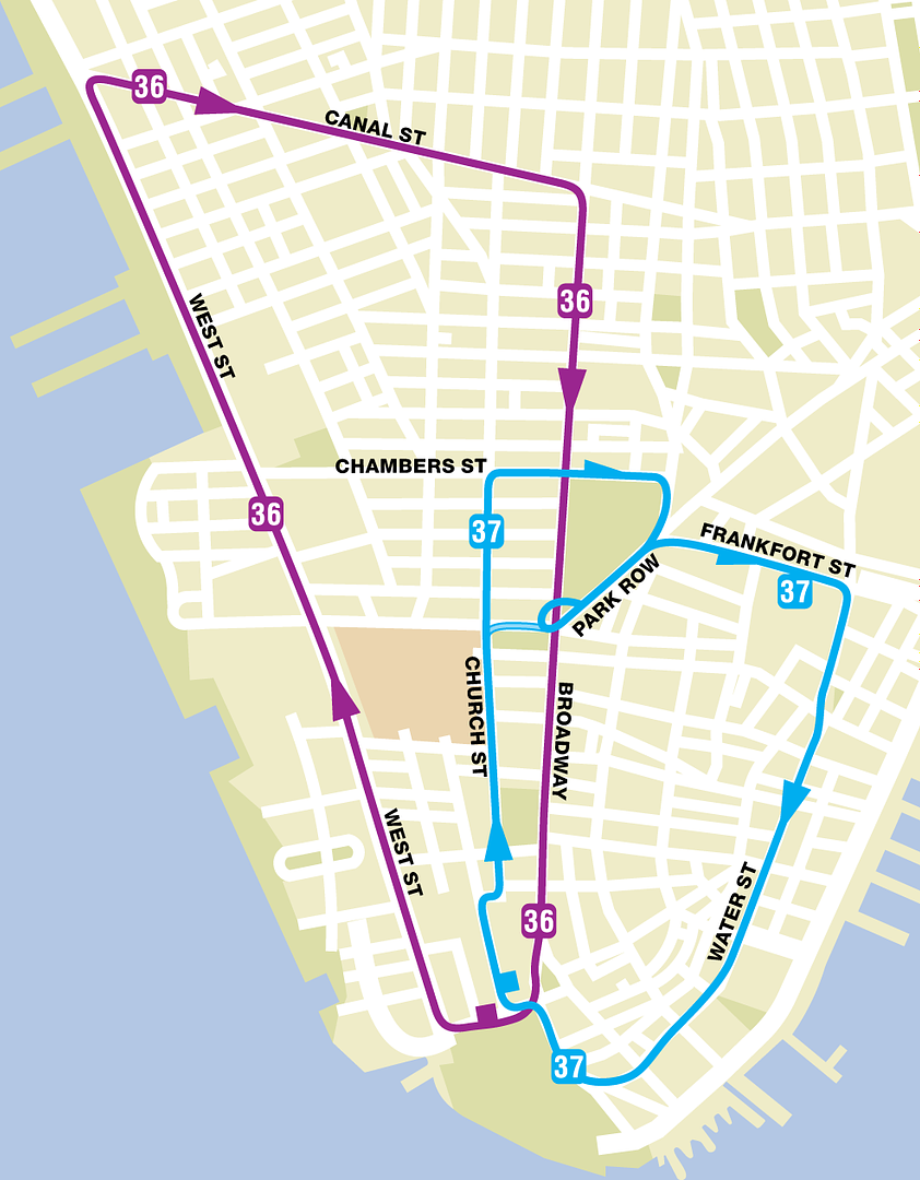
These loops operate on a weekday schedule. Both are clockwise, but serve separate areas. The M36 serves the western portion of Battery Park City, while the M37 serves both the central and eastern sections. Both terminals are on State Street near the South Ferry.
As you see, the M37 has a part-time route that doesn't serve Chambers Street and heads straight through City Hall. That operates only during the AM and PM rush hours.
The M36 should use the M20 route between Battery Place & Chambers Street.
The current routing could be used rush hours.
0 -
Oh you're referring to the headways. The headways aren't quite as good as the crosstown buses (mainly the M79 and M86). As much as I want to say that the M15 SBS has good headways, one afternoon on the weekend I waited 17 minutes (I timed it) at 42nd Street before saying the hell with it and hopping on the local, and when we got to 86th Street a select still hadn't passed us.
What time was it? A lot of buses run terribly in the night and on weekends. Even the B12, which on weekdays I have to say is one of the best buses in ALL the boroughs. Plus, the bad thing about SBS is if you run in to a situation like yours, that fare is gone if you used the machine already.
0 -
let me guess it uses linden blvd going ltd stops ehh? cause that is like an anti-car type of bus. M60 is never on time but it makes up for it in frequency.
Yeah, it uses Linden Bl, I say that in the doc. I'm not anti-car, I just do care a bit (sorry, a LOT) about the enviroment. I get angry if cars do less than 35 MPG. And about the M60: maybe it is like you said: you got lucky with the M60. I did a couple times too.
P.S. You are not a fan of capital letters, are you?
0 -
look at M60 you will be surprised.
Ohh I also saw buses and trucks on the grandcentral beyond astoria en rte to LGA so you are a bit off to an extent but mostly correct.
Besides I am the opposite of you I avoid manhattan buses like the plague yet I will gladly use buses in other areas like the outerboroughs LI and NJ and even CT. Manhattan buses are just too slow for me to take seriously except the M60.
Now that I think about it, the M60 isn't that reliable. When I lived in Manhattan, I used it to go shopping and it sometimes came in bunches. And I lived near the first stop in Manhattan.
0 -
Q61 would work best if it's express via lefferts blvd airtrain then nassau expressway direct to rockaway blvd you eliminate duplication and create a direct route that would attract many riders and transfer ppl too who want a faster trip to far rockaway.
Beat you to it B39 restoration is very similar to ur BQ1 idea as it stops in williamsburg and has transfer stops to
then express to jackson heights subway for many bus lines and subway lines then express again to LGA. Cause the line has no residential portions the ridership won't be affected so much by traffic and on time performance is low risk. Ohh before the others bash just giving the warning some ideas are best kept silent just take the ones you feel strongly about and talk with polititians rather than ppl here.If I came of a bit angry, I apologize. I don't want to start flame wars. About the BQ1: My bus goes to JFK, not LGA. But, I want my bus to stop in the Flatbush area because airport access from there is nearly impossible without a $40 cab, so it will really benefit the people who live there.
0 -
There is nothing wrong with the at Flatbush Avenue. Why would you change it in the first place? Here is something more real for you. Elevate the , and north of Flatbush Avenue, and have it run to Sheepshead Bay, Brooklyn. It would help the Utica Avenue residents, and the people in Sheepshead Bay.
(8) line in my project covers Sheepshead Bay section.
0 -
If the
 ever construts the SAS, they should have it connect with the just before Canal Street and have them run together. I will have the track map coming up in a few days.
I noticed service missing in the following areas (in red):
I will make some fictional routes tomorrow, I need to go to bed now lol.
If you check out my RUSH HOUR PROJECT, I accommodate for one of the missing service areas.
0
 ,
,  , (0),
  ever construts the SAS, they should have it connect with the
Overhead Destination Signs
in Artwork and Graphic Design
Posted
Can I have a bus stop?
B50|Spring Creek/JFK Airport
B50 SBS|JFK Airport
Linden Blvd & Church Ave