

RTS CNG Command
-
Posts
1,012 -
Joined
-
Last visited
Content Type
Profiles
Forums
Gallery
Downloads
Events
Blogs
Posts posted by RTS CNG Command
-
-
Yep, I do make signs. In fact, I was one of the people responsible for creating this wave of sign creativity.Well this I knew... I just didn't know that RTS made signs too, but for my express bus signs CNG and IRT are the best. B)
 2
2 -
Approval granted!I will ask RTS and Coneyislandav7 for their approval as I'm not the one that created the fonts. Once I get a response from them, then I'll be sure to reply here.
1 -
Re-merging the M10 and M20 would be overkill. The M10 and M20 were halved initially because M10 service was too long and infrequent. Now the M10's importance has been slashed again because its terminal is now 57th and Broadway.I'd use the M10 instead. Extend it instead. Even make it a limited downtown.
It couldn't even be limited-stop because its too infrequent. But I'm neutral when it comes to re-merging the M10 and M20.
My ideas are as follows:
1. Supplement service between the Yorkville Hospitals and Lower East Side via 1st Avenue, 2nd Avenue, and Delancey Street. This was a proposed idea a few years ago as a way to revamp the M21 and M9. The route was called the M13.
Here's my idea of it, courtesy of Gorgor's drawing of it: http://scaped.net/m/...CNG_Command/m13
2. Extend the M104 back to the U.N. to allow more breahing room for the M42 from the U.N. to 8th Avenue. Bus service on 42nd Street is a PITA with the overcrowding and M42 bunching in Midtown, especially during rush hour.
3. Extend the M10 to Times Square with the possibility of extending it back to Penn Station. The M10 has a smaller purpose now with it cut back to Columbus Circle. Extend the service to help give someone an option to travel transfer-free from Central Park West to Times Square without having to get off and wait for the M7, M104, or unreliable M20.
4. Echoed already: Restore the M5 and M6 to its pre-2010 cuts. And if not, restore Limited M5 service on the weekend.
0 -
NYCTF, Hell called. He said it's freezing down there: His bracket is busted.
0 -
I love you, too. <3Well, get up and shut up!There, that's better. ^^
———
And now for an unrelated note, I graduated from college and received a letter telling me I'm a candidate for valedictorian! I submitted my autobiographical essay, current résumé, and valedictorian form to the office. Now to wait for a reply.
0 -
Feel grumpy? Can't find a way to make you happy?
Well, get up and smile!
0 -
LMAO! Trollight Sparkle plus brony making flash animation of the audio equals stitches from laughter! XD
0 -
Yup. There have been quite a few changes lately. Lance25 is now a moderator here.I hand't been here since the summer time,I see alot of stuff on this site had change....Shorline bus is a forum staff now??what is this world is coming too! 0
0 -
A revision of the M9!
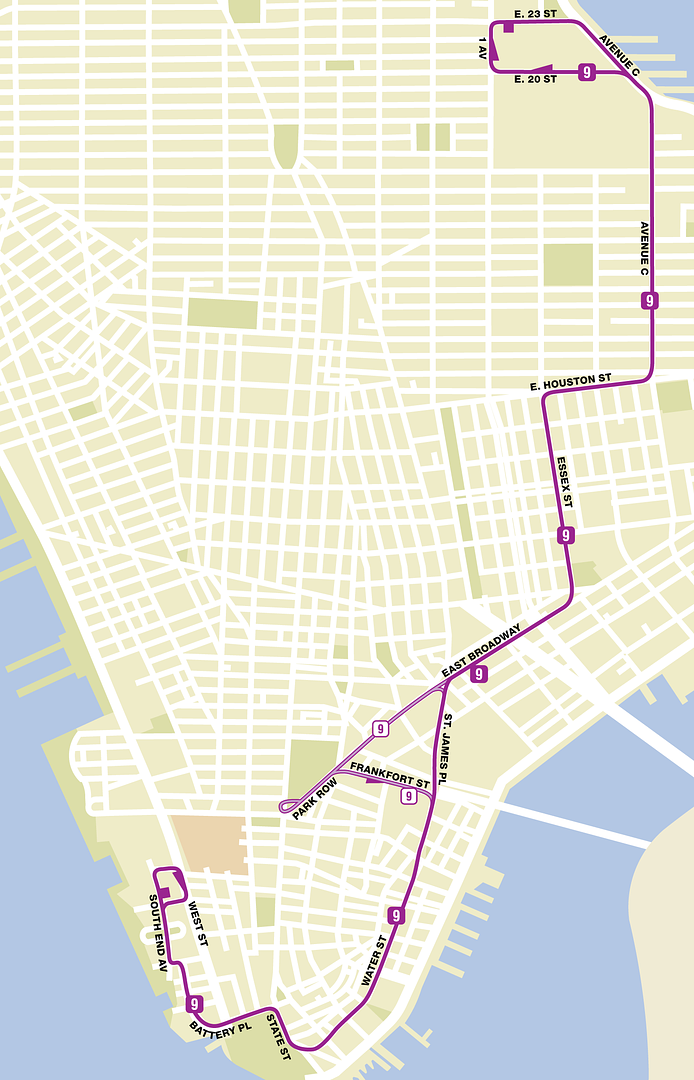
This one takes the current northbound terminal and both southbound terminals. But instead of two south M9 terminals, the new M9 would be reinstated down Water Street and loop around Battery Park City like it were prior to the 2010 cuts.
While the City Hall terminal's eliminated, the route isn't. During midday and rush-hour weekdays and Saturdays, the M9 would loop in Park Row. Heading to Battery Park City, it would turn on Frankfort Street. Heading northbound to the Veterans Hospital, it'd just keep traveling north on Park Row back to East Broadway.
0 -
Two new Manhattan fantasy routes!
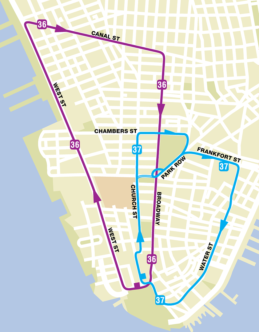
These loops operate on a weekday schedule. Both are clockwise, but serve separate areas. The M36 serves the western portion of Battery Park City, while the M37 serves both the central and eastern sections. Both terminals are on State Street near the South Ferry.
As you see, the M37 has a part-time route that doesn't serve Chambers Street and heads straight through City Hall. That operates only during the AM and PM rush hours.
0 -
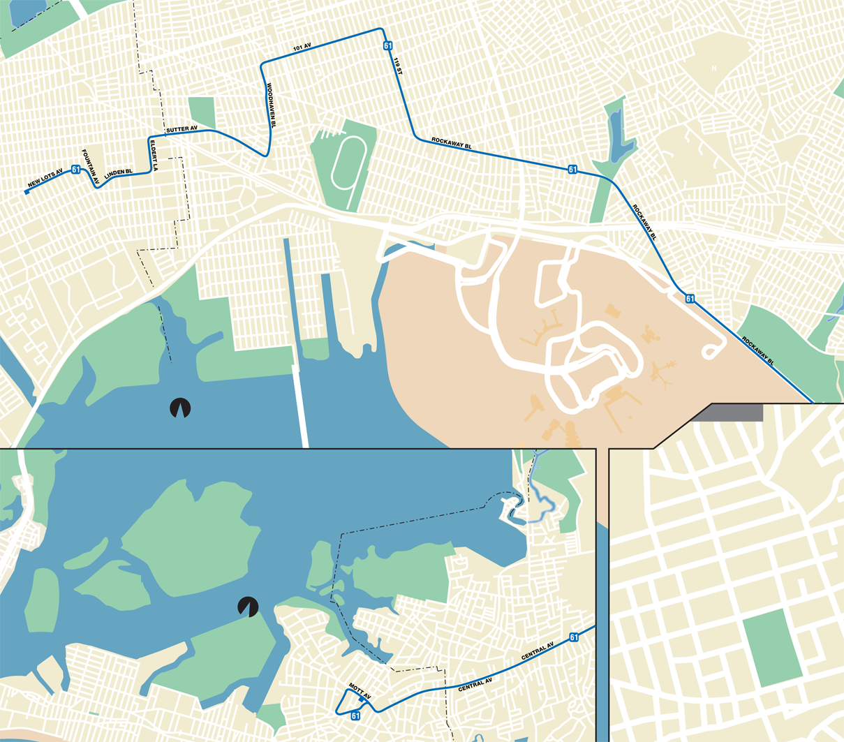
It'd be wishful thinking, but between 23rd and 125th street, buses and trucks aren't allowed on the FDR/Harlem River Drive.Couldn't you use the FDR to get to the RFK(Abbrevations!) since it's a super exp?Q61- East New York- New Lots Avenue Stationto Far Rockaway-Mott Avenue Station
Far Rockaway Bus Depot
 0
0 -
Or maybe revert this to an express called the X91?Couldn't you extend it further north to 72nd Street & York Ave, or even 91st Street to service Yorkville & the Upper East Side.In fact, let me twist it up.
The X91 from Yorkville to LaGuardia Airport!
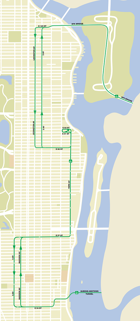
Some things about this route.
1. The stops for the express are represented by a diamond. The purpose for this is to designate WHERE you're allowed to enter the express bus. The Madison Avenue section doesn't have these stops for that reason.
2. There's a section that turns on 86th Street towards LaGuardia. This is the Super Express version for those who live in Yorkville, yet don't want to have to wait for the regular X91 to make continuous stops en route to LaGuardia. There are only two SEs each way.
0 -
I wasn't really thinking of just the LIRR. It's really more of a method to provide direct Limited-stop bus service along Myrtle Avenue from Jamaica to Downtown Brooklyn.How would the B85 benefit passengers? A direct route to Jamaica from Downtown Brooklyn? There's already the LIRR service that terminates at Atlantic-Flatbush Avenues, along with the A train at either Jay or Hoyt-Schermerhorn Streets to Broadway Junction and transfer to the J train into Jamaica.0 -
B85 Limited from Jamaica-LIRR Station (the terminal of the Q30/31/43) to the Fulton Mall.
Westbound:
Turns on Archer to Sutphin.
Turns to Jamaica Avenue.
Turns on Myrtle.
Turns on Flatbush Avenue.
Turns on Tillary.
Turns on Jay Street. Terminates at Willoughby Street.
Eastbound:
Turns on Fulton.
Turns on Flatbush.
Turns on Myrtle.
Turns on Jamaica Avenue.
Turns on 146th Street.
Turns on Archer Avenue. Jamaica terminal.
Westbound stops:
1. Archer/Sutphin.
2. Jamaica Avenue/Van Wyck
3. "/Lefferts Blvd.
4. Myrtle Av/Woodhaven
5. "/61 St.
6. "/Ridgewood Terminal
7. "/DeKalb Av
8. "/Marcus Garvey Blvd.
9. "/Nostrand Av
10. "/Bedford Av
11. "/Vanderbilt Av
12. "/Flatbush Av
13. Jay St/Tillary St.
14. "/Willoughby St (terminal)
0 -
I'm in a very shocked mood right now.
Aside from here, I go to the Sonic Stadium Message Board. Like here, we're a very close, tightly knit Sonic fan-community where we converse, deal with issues, and talk about everything Sonic.
Well, we just found out that one of our most prominent and well-known members, Modern Daz, has been diagnosed with stomach cancer. I don't know the stage, and I don't know him that well, but it shocked me, especially since the dude's a great contributor and a great person to talk to.
Get better soon, Daz!
0 -
After owning a great iMac for six years and another one that's run very well, too? I think I'll pass.Dell is rubbish. Buy HP 0
0 -
The old PowerPC iMac I had from July 2005* to August 2011 and Intel iMac from August 2011 to today makes me very happy that I don't have that bull rubbish called a Dell PC again.
*Mom owned it for two years prior to July 2005, but used it sparingly, so when my Dell went kaput, she gave it to me.
0 -
New updates with my map!
1. Adding the M24 SBS.
2. Adding the B71 and B77 extensions to South Ferry.
0 -
Another day, another update! This time, I added an idea of my own, the M90 Limited from Central Park North to Battery Place. With the exception of traveling to Battery Place, it's essentially the old X90 route pre-June 1996.
EDIT: Fixed a little error with the Limited dots and M92A and M92B squares.
0 -
It takes around ten to fifteen minutes to empty out the map. How I do it is just save the Inkscape file as an EPS or SVG (without text) and then open it in Illustrator. There, I consistently select an object, go to "Select" ----> "Same" ----> "Stroke Color" or "Stroke Weight" or whatever, and I clean it up.How long does it take to clean up the (original bus) map using Inkscape & Illustrator ?Reason I ask.... I've long been looking for a bare boned map of Brooklyn so I can draw all my ideas onto it.... Tired of drawing out routes on google...
Note that I HIDE the data by either placing them under a different layer and hitting the "eye" to show/hide or Command+3 to hide it. I tend to creating new layers and transporting the old data onto them so I can use them for later.
You'll see.Why not just label one the M90 and the other the M92? Also no real point in sending the M92A around to the World Financial Center if the M92B is already there. Everyone heading to/from there would just take the M92B.
0 -
Excuse me for double-posting, but I have a map update!
The update is the M92 Limited from Yorkville to the World Financial Center, but as two branches: the M92A through Water Street and South Ferry (basically the old X90) and M92B through Tribeca, City Hall, and Chinatown.
0 -
That is correct.Thanks!And downtown it would follow the pre-2001 X90 route (the former X25 route), correct?
0 -
The old X90 would cut through 23rd and then head up first Avenue to 79th Street and then progress into Madison Avenue to 110th Street. Going south, it'd travel down 5th Avenue, turn on 79th, and then down York Avenue, following the old X92 route until exiting FDR.How exactly was the route of the old X90? I could never find any information on it. Did it cut over to the FDR on 23rd or follow the BxM18's route?0 -
@Dan: Maybe I will add the X90 and X92, but in a different format: the old X90 that went to Central Park North and X92 that went to Water & Broad (although my ideas are to make them limiteds and have the M92 LTD extend to the World Financial Center via Water Street B)).
That said, I updated my map with another one of my own route ideas: the M12 (in lilac coloring) that travels from Grand Central to South Ferry.
0
Off-topic Random Thoughts Thread
in Off Topic Lounge
Posted
Back in the good ol' days of Major League Baseball, there used to be quite a bit of fighting. And, no, I don't mean a simple bench-clearer or a simple mound-charge with only the pitcher and better ejected. I mean REAL bench-clearing brawls, where the fighting spills out and gets very nasty. Basically equivalent to the WWE. Sometimes, it gets so nasty that we may see as many as six, seven, or eight ejections for one fight or a series of fights that happen during one period. Today, we don't see these kinds of heavy-duty scraps unless you're watching a minor-league contest.
There's one underrated brawl that's just popped up on YouTube: the 1990 Brewers-Mariners brawl. Check out this clip:
http://www.youtube.com/watch?v=tk8Ekkzxh4k&feature=related